Unprecedented heat in South Australia - 24 January 2019
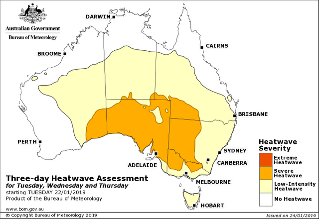
An unprecedented hot day across Southern Australia today, particularly in the State of South Australia where around 27 all-time daytime maximum temperature records were broken, including Adelaide (Kent Town) with 47.7°C (117.9°F) and Port Augusta with 49.5°C (121.1°F). This is the third severe heatwave to affect southern Australia since Christmas.

Australian Bureau of Meteorology heatwave product for the 3 days starting Tuesday 22 January 2019.
This latest heatwave, although not as prolonged as the previous two heatwaves, but producing higher daytime maximum temperatures for a single day is a classic example of exacerbated heat over southern Australia due to the direct influence of tropical convection.

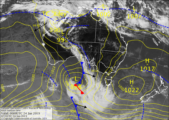
Australian Bureau of Meteorology satellite and Mean Sea Level Pressure analysis valid 06 UTC (16:30 ACST).
Excessive heat has been building over the interior Australian desert for sometime with the lack of strong cold fronts to "flush" this heat from the Austrialian continent. This has lead to a semi-permanent but meandering upper-level ridge (an airmass of warm air rotating in an anti-cyclonic or anti-clockwise direction). Anti-cyclonic Potential Vorticity generated in the upper atmosphere due to latent heat release from Tropical Cyclone Riley, a Category 1 system, off the northwest Western Australia coast is materially advected over southern Australia by strengthening northwesterly winds through depth ahead of an approaching vigorous cold front and associated low-pressure system over the Great Australian Bight, intensifying the upper-level ridge. Meanwhile, this advected air descends and in doing so, warms and dries adiabatically. Daytime heating allows thermals to rise and tap into this warm and dry air aloft and transports it to the surface as wind gusts via convective over-turning. This is why observation sites can suddenly record hotter and dryer conditions while promoting dangerous fire weather conditions.
Woow heatwaves are breaking daily high records, cannot imagine how hot the temperature is over 40, here In Costa Rica it does not get over 35 in few places but humidity is usually very high which feels different from other kind of hot temperature feelings.
It's definitely oppressive @raserrano! We are expecting 44°C where I live today so going to be very hot; a great day to stay inside and play board games with the kids 👍
A work colleague is currently holidaying in Costa Rica and I must say, gauging from his photos, it looks beautiful there! Definitely agree about the humidity. I've been to Darwin in the Top End of Australia's Northern Territory during the build up season (pre-monsoon) where temperature is similar at around 35°C but humidity around 80-90% which makes the Apparent (Feels Like) Temperature more like 40°C. It's certainly a different type of heat.
Thanks for the reply
Posted using Partiko Android