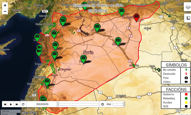
#qgisUnmoderated tagAll postsExplore CommunitiesTrending CommunitiesSteemit FeedbackNewcomers' CommunitySteemitCryptoAcademyআমার বাংলা ব্লগKorea • 한국 • KR • KOSteem AllianceSTEEM CN/中文WORLD OF XPILARAVLE 일상SCT.암호화폐.CryptoComunidad LatinaTron Fan Club#qgisTrendingHotNewPayoutsMuteduribarrix (28)in #python • 6 years agoAgora, si. Re-comezamos.Xente, levou máis do que dixen, pero xa estou. Vou comezar sen dar moita volta. Vouvos ensinar a facer un mapa en…routhwick (41)in #geofiction • 6 years agoCeci n'est plus pas Rogatie. (Au moins, j'essayais...)If you haven't figured out from recent posts, I'm relating to Rogatia, where part of my forthcoming Sevton Saga is…routhwick (41)in #maps • 6 years agoTo pardon a project-relevant pun...dropping right back in.To paraphrase Mark Twain (as this feed turns seven with barely any fanfare): If any rumours of my disappearance may…routhwick (41)in #maps • 6 years agoSpeaking of the Rogatia project I mentioned last time...TL/DR: The map I always wanted to do for ages is back with a vengeance--recent setbacks/events or not. Words cannot…routhwick (41)in #thoughts • 6 years agoSailing right back in...after eight weeks away. (Read on below.)TL/DR: This Captain still can't catch a good break, new platform or not. Apologies for the long, LONG break since…smk762 (27)in #qgis • 7 years agoPart Three - Exporting Avenza Maps catured GPS tracks and placemarks into QGISLink to earlier parts: Part One - Using Avenza Maps and QGIS to create custom maps for free treasure hunting Part…smk762 (27)in #geocache • 7 years agoPart Two - Hidden treasure in your local parks: Using Avenza maps to GPS your geocaches and the path of your treasure huntLink to part one - Using Avenza Maps and QGIS to create custom maps for free treasure hunting Geocaching is…smk762 (27)in #geocaching • 7 years agoPart One - Using Avenza Maps and QGIS to create a base map for treaure huntingWe are fortunate to live in an age where we have free access to software allowing accurate location data capture with…pasq2al (32)in #french • 7 years agoCarnet de travail avec atlas QGISLa saisie sur ordi, c’est bien mais des fois, il est plus pratique et rapide de sortir sur le terrain avec quelques…pasq2al (32)in #adullact • 7 years agoAdministration et logiciels libresComme l'année dernière (cf. mon article de 2016) , et comme tout les ans. Le SILL [note] Socle Interministériel de…pasq2al (32)in #carte • 7 years agoPetit exercice de cartographie (3)Comme indiqué dans la partie 2, cet article va nous permettre de rajouter les principales failles sismiques du…pasq2al (32)in #assistant • 7 years agoPetit exercice de cartographie (2)Suite de la partie 1, si vous avez suivi le précédent article, vous avez une carte de France avec des points…pasq2al (32)in #cartographie • 7 years agoPetit exercice de cartographie (1)Comme vous l'avez sans aucun doute lu dans l'article ici, j'ai suivi le MOOC cartographie. Je vous présente donc la…pasq2al (32)in #expressions • 7 years agoConstructeur d'expressionsOn ne peut se passer d'une méthode pour se mettre en quête de la vérité des choses. René DESCARTES Après le premier…pasq2al (32)in #ilike • 7 years agoLes requêtes du GraalDans un autre article, nous avons monté un pseudo-cadastre. Mais comment chercher. Quelque soit le fichier, il est…pasq2al (32)in #polygones • 7 years agoSymbole unique - PolygonesDonnons du style [wpfmb type='warning' theme=1]ATTENTION, MESSAGE PREVENTIF : J'ai des goûts de ..., ne pas forcément…pasq2al (32)in #graphique • 7 years agoModélisation boite à outil QGIS et urbanismeTiens, en attendant que je finisse tous les articles que j'ai commencé sans les finir, je me lance dans un nouveau…crob (46)in #vincentb • 7 years agoGeographic Information Systems - DesktopESRI has been the leader for many years, but the open source movement is making gains. QGIS is a great free and…romyjuanda (37)in #gis • 8 years agoSimple Webgis With LeafletsHi all ... here I want to share a little how to create a simple webgis with leaflet, to build a simple static webgis…rajamuchlisar (32)in #video • 8 years agoHow to create line in Quantum GIS ( QGIS )