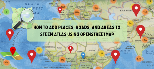
Steemit Challenge Season 24 Week 05 - How to Add Places, Roads, and Areas to Steem Atlas Using OpenStreetMap
Hello everyone!
I warmly welcome you to the week 5 of the Steemit Challenge about Steem Atlas. As this is all about teaching Steem Atlas and I am going to teach an important part of Steem Atlas so that the users can easily use it. I will teach you how you can register or add your places or any other place to Steem Atlas map. Steem Atlas uses an open source map OpenStreetMap to display the map on the website and use it to pin the locations. It is very important to understand and learn this map.
To perform different operations on the OpenStreetMap we need an account. For the creation of the account follow these steps:
- Go to https://www.openstreetmap.org/
- Click on Sign Up
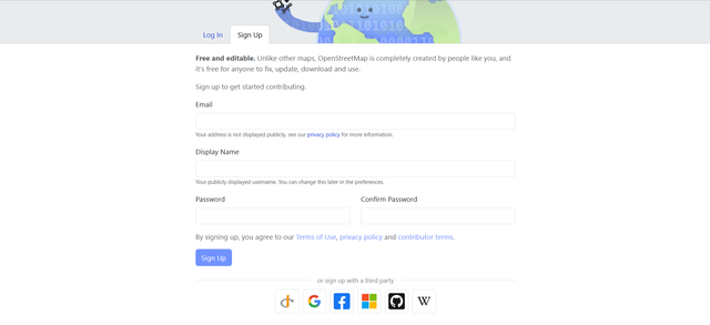
- Give email
- Give your display username
- Choose a password and confirm it

You can also sign up with other social media accounts such as Google, Facebook, GitHub or other. After this OpenStreetMap sends a confirmation email to the given email. It is necessary to confirm the email from that link to start editing and using the map. Now you can log in and start editing the map.

After logging in it looks like this. At the start of the menu there is a dropdown button for the editing. It has two further options for the editing.
- Edit with ID
- Edit with remote control
Edit with ID:
This is a web based tool for editing OpenStreetMap. It is beginner friendly and easy to use and it does not require to install or use any extra tools. It is very easy and useful to add the missing points or editing small tasks.
Edit with Remote Control:
This is a desktop version for the editing of the map. It is for the advanced users who have experience with java. It requires the installation. It is used for the advanced features. It also supports offline editing. If the user wants to handle the large amount of data then it is suitable for handling large data.
For the editing of the map we will use the first method (Edit With ID) which is easy to use and does not require any separate installation or knowledge of the programming languages.

There are three options in the map to add new things in it. These are given below and I have highlighted all these three options:
- Point
- Line
- Area
Point:
This is used to add restaurants, monuments, post boxes, or other similar points on the map.
Line:
This is used to add the roads, footpaths, streets, canals or other similar things which are represented by the lines.
Area:
This is used to add the parks buildings, lakes, or other ares on the map. We can add square or circular areas on the map.

When we add anything in the map using one of these 3 tools then we see a section of features on the left side with the search box. This appears automatically as soon as we click on the map by using any feature from the point, line or area. It shows different features such as restaurant, park, playground, hospital, cafe and more. We can also search if we do not see our targeted option. This works like a tag for the place.

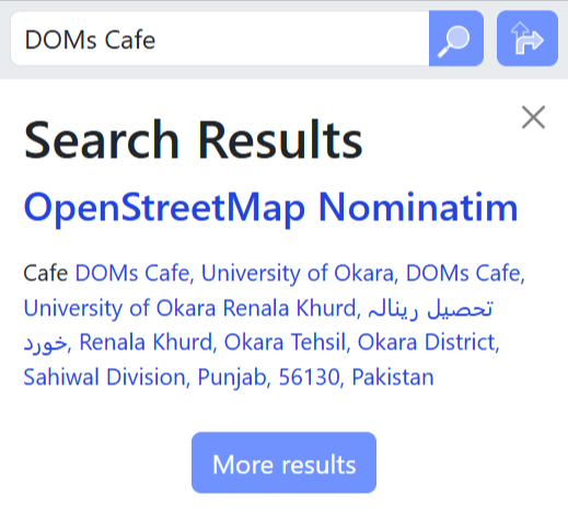
To add the place we have to zoom in the map to that place. In the above picture I have zoom in to the university of Okara and in this university the DOMs Cafe is not present on the map with the pointer and it is difficult to pin the post related to this cafe on Steem Atlas so I am adding it to the map.

I have used point tool to add this cafe on the map. After adding it we need to give all the details bout the place. We can also leave some fields blank but if we add all the details then it becomes more useful.
 |  |  |
|---|
After selecting the building and mentioning it as a cafe I have added all the other relevant details about this cafe. If we want to add additional information then we can add the fields manually. At the end we can see the summary of the information added about that place.

After adding all the changes we need to click on the Save button. It gives a hover message that review the changes and save it to upload the data on the map.

Before uploading it requires a changeset comment which is required to fill. It is required to tell the community about this change why we have added any location or why we are changing the map. Without adding this comment we cannot upload the data.
I have uploaded the data on the map. It took a few seconds to upload the data but it takes some minutes to update the location on the map. It may also take longer than a few minutes to display the place on the map.
 |  |
|---|---|
| Before adding | After adding |
Before adding I searched the cafe on the map but it was not available in the search results. After adding it into the map and waiting for its visibility I searched it again and the cafe is visible in the search results.

Similarly the cafe is available and visible on the OpenStreetMap. After its appearance here on the OSM map now it should also dispaly in the steematlas.com.

Finally I have opened steematlas and searched for this cafe of the university and we can see the cafe is visible and updated to steem atlas as well.
In this way you can add any place or building on steem atlas map just by adding it to the open street map.
Adding a bridge/Road/Footpath

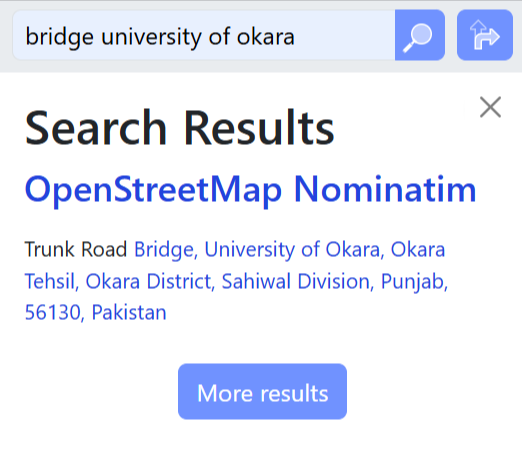
In order to add a road, footpath or the bridge there is the same tool. We have to use line tool to add these things. Currently in the above picture you can see the university are and the main road. But in reality there is a crossover or the bridge of the university which is used to cross the main roads and the students can easily enter the university without the traffic fear. As this bridge is not visible on the map I will add it to make it look visible.

After opening the map in the editing I have found the bridge of the university and I have highlighted this bridge for visibility with the white rectangular box. Now I will add this bridge on the map.

Here you can see I have drawn the bridge of university of Okara which is used to cross the highway roads and the railway track of the train. Now on the OpenStreetMap soon it will appear and similarly in the steem atlas. In this way the users can add any road, footpaths or bridges by selecting the line tool.

Here you can see the bridge is appearing on the map.
I have searched the bridge which I have added recently and you can see the bridge is on the map.
Adding an area
Sometimes we need to add an area on the map. I will give the example. University of Okara is available on the steem atlas map but not its departments area wise and name wise.

Here I have highlighted the department of Computer Science which is not registered as the department on the map. I will add it on the map right now while guiding you. We will use area tool to add the boundary of this department.

I have surrounded all the area of the department of Computer Science with the number of nodes. But we can see the nodes are not looking aligned in the square form. And we need to fix this alignment of the nodes surrounding the building.

Right click on the boundary and it will show the options such as square, circle, flip and more. If we want to make our boundary in the circular form according to the shape of the building then we need to choose circularise and if we want to make the boundary in the square shape then we need to choose the third option. As this is in the square form so I have chosen the square option.

Here we can see the boundary of the building is looking more accurate and aligned after making it square.

Here you can see the department of Computer Science University of Okara on the map. It will take sometime to become appear on all the maps which use OpenStreetMap API.

Here you can see right after adding this building to the map I have searched it by the given name and we can see the search result. This is available on the map.
In this way we can add buildings, missing places, roads, footpaths, bridges, canals, or anything to steem atlas by using the three tools, Point, Line and Area.
Note: It can take time to appear the place on the map you add so do not be worried just add it correctly and it will appear in a few ours on Steem Atlas map.
Homework Tasks
- Add one shop or business on the OpenStreetMap.
- Add one cultural / religious / educational place on the OpenStreetMap.
- Add one item of your choice on the OpenStreetMap.
- Show the steps you followed to add all the places you add on the map and provide their link from the OpenStreetMap.
- After adding the places select one place which you added and review it.
- While reviewing the place please keep in mind the 21 Tips to Create Better Posts for Steem Atlas.
Rules and Regulations
Publish your posts on your personal blog or community of choice.
Keep your title short and to the point.
Write in short, concise and clear paragraphs. Posts must be free of plagiarism and not use Artificial Intelligence (AI) or other forms of cheating.
Participants are prohibited from reviewing places that you have previously reviewed on Steem-Atlas.
Participants may only share their own photos (required).
We recommend that you use hashtags in the following order # typeofplace # city # country #steematlas-s24w5.
Support the growth and development of the Steem Atlas project by setting beneficiary to @steem-atlas.
Invite 3 friends to participate.
Paste your participation link in the comment section, and don't forget to Vote and Resteem this post.
This contest starts from Monday, May 19, 2025 and ends on Sunday, May 25, 2025, at 23:59 UTC.
Rewards System
Sc01 and Sc02 will be visiting the posts of the users participating in the Steemit Challenge and upvoting outstanding content. Upvote is not guaranteed for all articles. Kindly take note.
Each week we will select Top 6 posts which has outperformed from others while maintaining the quality of their entry, interaction with other users, unique ideas, and creativity. These top 6 posts will receive additional winning rewards from SC01/SC02.
Note: We will choose the winner based on the quality of the post. Posts that are considered quality are those that follow the 21 Tips mentioned earlier. In addition, our team considers that a quality post should be able to provide specific information and new insights to its readers. Proper use of markdown is also an important aspect in determining the quality of a post. Make sure to pay attention to all these elements to get your post selected!
On the same time you participate in the Prize Pool Of 3300 STEEM. Each week the winners are announced for the Atlas Challenge. This is an exclusive rewards during the Steemit Challenge Season 24.
This is an excellent way to help improve the coverage of the OpenStreetMap system that we use for Steem Atlas.
Yes indeed it will help the users to register or add the places such as shops, parks, restaurants, educational institutions and much more that they want to see on Steem Atlas.
Here's my participation:
https://steemit.com/hive-161285/@hudamalik20/openstreetmap-malik-feroz-khan-noon-business-school
I might need a thorough study on how to apply this tool, btw bro, is this applicable to mobile phone?
Yes my friend it can be used in the mobile phone but if you use desktop then it will be one more easy.
Okay bro, I will study more on the process in my mobile phone. Thanks for the reply.
This is a very good initiative because when I look at my surroundings through Steem Atlas, I notice that there are many important places that are not yet listed on Steem Atlas.
Through this contest and with the help of this guide, I will be able to add those places to Steem Atlas. And thank you very much for explaining the method I will follow all those methods.
Good to know that you found it helpful.
Hay bastante información, lo intentaré, ¡me gusta! y me parece interesante poder ubicar y reseñar nuestros lugares habituales.
Good to see that you found it informative.
He intentado registrarme, pero me envían a una dirección de e. Mail para solicitarlo desde allí. Es posible que no funcione desde Venezuela. Me tocará esperar y no creo que pueda participar por el tiempo del concurso.
Try by registering with Google or any other social media direct link. I don't think that it has any limitations for Venezuela. It is an open source map. Did you receive email?
Ya me respondieron gracias!
Wonderful. Looking forward to seeing your entry.
@mohammadfaisal
I am confused with this point i means what type of item? Please help.. i am also texting you on WhatsApp please reply
One item of your choice means you need to add any place except the places listed here:
Oh ok ok.. one place there is a huge diff between place and items..
https://steemit.com/hive161285/@bahrol/steemit-challenge-season-24-week-05-how-to-add-places-roads-and-areas-to-steem-atlas-using-openstreetmap-aci-aqf-kupi
Tantangan yang harus dicoba, karena menurut saya tantangan ini juga bisa menjadi ilmu. Tantangan yang sangat menarik, semoga teman teman semua bisa mengikuti tantangan ini.
You are warmly welcome to this challenge. I hope you will learn and add new places on the map.
Siap, akan saya laksanakan, saya akan melalukannya sesuai dengan jadwalnya nanti.
my entry post https://steemit.com/steematlass24w5/@isha-rehman/adding-govt-girls-college-phase-7-hayatabad-to-openstreetmap-or-steemit-challenge-s24w5
Hi, everyone
My entry for week 5
https://steemit.moecki.online/road/@joslud/steem-video-23-id-8719